
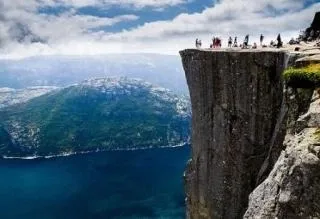
Preikestolen
Bergen, a member of the Hanseatic League of free trading cities, is eighty years older than Moscow and was even the capital of Norway in the thirteenth century. For almost its entire long history, the city traded dried cod: bought from fishermen in the north of the peninsula, sold to merchants in the north of the continent.
For at least three hundred years, Bergen has greeted travelers with the same landscape as today: a square main square, a fish market with the morning catch, tightly packed rows of colorful houses (so that a returning sailor could see them from afar). Their gingerbread beauty is so genuinely delightful that you hardly believe it is a very careful reconstruction of what survived numerous fires.
In the 20th century alone, Bergen burned twice, in 1916 and 1955, and there was also a colossal explosion in the port of Bergen in 1944, when on Adolf Hitler's birthday, 124 tons of explosives detonated in the holds of the Dutch cargo ship 'Forbode' that had come for repairs. Sabotage was suspected, but the investigation showed that the cause of the explosion was spontaneous combustion. The wave raised by the explosion threw ships that had entered the harbor onto the shore and destroyed part of the embankment. Urban legend says the wave height was over a hundred meters. There is no photographic evidence of this, but the anchor of the 'Forbode' was later found on one of the seven hills surrounding Bergen, at an altitude of nearly 400 meters.
In Bergen begins the road to Hardanger – a region surrounding the third longest Norwegian fjord (less than an hour's drive to the water).
With its shape resembling a person in ecstatic dance, the Hardangerfjord with its branches extends more than 100 km inland. Two-lane roads accompany it almost along its entire length. The views are magical, but the driver will have to look not around but exclusively ahead, so as not to inadvertently leave his lane. The mountains along the fjord banks rise so steeply that reclaiming an extra half meter of width for the road is a sheer luxury, so the width of the road along the fjord equals the width of two cars plus ten centimeters for the dividing line.
Like all fjords of Norway, the Hardangerfjord owes its existence to a glacier that covered this land with a three-kilometer layer two and a half million years ago. As it receded, the glacier deeply tore the rock. Now water divides the mountain in a ratio of about two to one: a thousand meters above water (and some even fifteen hundred) and another five hundred below water (maximum depth is almost 900 meters). If there is anything in the world that so easily rehabilitates and brings back to reality the metaphor of 'water surface', it is the water of the fjords – stretched evenly, very evenly, without a wrinkle, a thick gouache blue. This pedantic evenness and smoothness reflects the world above so plausibly and distinctly that dizziness is not far off: above your head is the sky, under your feet is the sky. And where are you? Nowhere. You don't exist at all.
Near the ancient town of Utne – the shorter and simpler the name, the older the Norwegian settlement – the Hardangerfjord branches into three arms. The one that goes east ends at the Sima valley and finishes in a dead end of water as calm as everywhere. You would never guess that one of the most powerful hydroelectric power plants in Europe is hidden here. All the rooms of the power plant are inside the mountain: the 200-meter machine hall and the 700-meter shaft cut into the rock. Tours of the machine hall are held three times a day – you just need to put on a helmet, and at Christmas, jazz concerts are given right among the turbines. Even the ten-meter rotor displayed in the hall does not spoil the acoustics. It has already served its time, but still shines like new.
The first hydroelectric power plant appeared here almost a hundred years ago in the mountains above the Sima valley, in the tiny village of Kjesen. The father of the family, a farmer, built a micro-hydro plant for his own use. His daughter, a kind-hearted lady over 80, still lives in the farmhouse (though it is no longer lit by its own electricity) and receives guests. As a child, she walked to school in the valley, daily overcoming a climb and descent half a kilometer in height; now you can get to Kjesen by car. The road carved into the mountain is narrow, so traffic here is reversible: traffic up every hour on the hour, traffic down every half hour.
From the Sima valley, it is not far to the most famous Norwegian waterfall – Vøringsfossen, a column of white boiling water with a drop of 182 meters. Here and there, small clouds of water vapor break away from the falling water, only to shatter against the edge of the stone bowl that encloses the waterfall. At the top and bottom there are observation decks with parking and souvenir shops. From the top to the bottom it takes an hour and a half on foot, and you need to look not only at the falling water but also sometimes at your feet, so as not to trip over the thick-stemmed birch boletes.
At the nearest tourist center attached to a small museum describing the nature and lifestyle of the inhabitants of the Hardanger plateau, it is worth watching a fifteen-minute panoramic (on five screens) flight simulator film over the valley, fjord, and waterfalls. The simulator is very honest: it will make you seasick within five minutes. Here is also a large center for water and mountain activities, Flat Earth Adventures. You can go kayaking on the fjord even in winter; a wetsuit and other gear are provided on the spot.
Continued: NORWAY: A VIEW FROM ABOVE - 2
Maria ZHELEZNOVA.
