
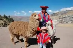
I chose Cusco as my first stop in Peru. The bus carrying me from neighboring Bolivia made a single stop along the way at the border crossing between the two Andean countries, right next to the waters of the famous Lake Titicaca. The sun had already disappeared somewhere in the Andes by the time we arrived at the city bus station.
Cusco is the brightest flower in the bouquet of Peruvian cities. A mountain flower that blooms in harsh conditions and reaches higher and higher toward the sun. The Inca Empire, which once existed at such altitudes and was once and for all overthrown by the Spanish conquistadors, left the most significant imprint on the South American continent. Knowing neither the wheel nor writing, the Incas achieved perfection in the construction of religious structures. Considering the Sun the creator of all things, they built unimaginably rich temples for it, earning the poetic name "children of the sun."
Present-day Cusco, with its no less remarkable surroundings where numerous castles, temples, fortresses, monasteries are located, is one of the most visited tourist destinations in Latin America.
Before the arrival of the conquistadors led by F. Pizarro in these lands, Cusco was the capital of the Inca Empire with many monumental stone structures. At first glance, the city clearly reveals itself as an example of classic colonial style. However, it is notable not for this, but rather Cusco earned its greatest value and uniqueness thanks to its eclecticism, uniting two architectural traditions—Inca and Spanish. The fact is that over the course of several centuries, when rebuilding the city, the Spanish, out of practicality, did not destroy the solid foundation of the previous structures, but built theirs on top of the old masonry. There are many such buildings in the city, but two cathedrals stand out: the cathedral and the neighboring Compañía de Jesús de Cusco on the city's main square, Plaza de Armas.
Cuscovie
North of Cusco, just a few kilometers away, are some of the most famous Inca structures that are part of the so-called "Sacred Valley."
The closest of them is Sacsayhuamán, which is a powerful zigzag three-tier defensive wall. The length of each rampart is about 360 meters, the height of the stone blocks on the lower level reaches 9 meters, and they weigh more than 300 tons. No mortar was used in the construction of the fortress, and most modern scholars believe that the builders of the citadel possessed a previously unknown method of softening rock. Sacsayhuamán is located at an altitude of 3,500 meters above sea level and offers its visitors a fantastic view of Cusco itself, lying as if in a lowland surrounded by mountains on both sides.
Two kilometers from Sacsayhuamán you can see the temple of Kenko, carved into a small limestone rock. In the Quechua language, this word means "labyrinth" or "zigzag." And indeed, when you look inside the cave, you find yourself in a winding passage with niches in the walls, next to which stands a stone pedestal carved from solid rock and polished, used in sacrifices and embalming.
Moving further north from Kenko and gradually climbing another hundred and fifty meters upward, you come across a fortification called Puca Pucara ("red fortress"). The fortress is especially impressive in the light of the setting sun, when the valley in which it is located is flooded with ruddy light, and the stone stairways, arched passages, and niches (the main elements of the complex) truly take on a red color.
For a traveler unaccustomed to high altitudes, a day spent in the "Sacred Valley" may seem overly tiring, so at the end of visiting all the significant sites, I recommend visiting Tambomachay, which is a few minutes' walk from the Red Fortress. This is a very quiet, peaceful, and picturesque place that was originally intended by the Incas as a place of rest. Tambomachay is also known as a temple dedicated to water. The multi-level structure was built about 600 years ago in such a way that water flows by gravity from the neighboring mountains and, passing through several cascades, flows into a ritual bath. The water, as before, flows from two spouts into the stone reservoirs of the temple. Unfortunately, visitors to Tambomachay are not allowed near the bath, but by stealing a few seconds, one can try to do so. Especially since there is something worth risking—according to local beliefs, by partaking of the water from this holy spring, one can remain young forever.
Machu Picchu
While in Cusco, by contacting any local tourist office, you can obtain the most detailed information about visiting Machu Picchu. On average, to see one of the most impressive architectural ensembles in Latin America, you will have to spend $120–130. This amount includes the cost of a train ticket departing from the outskirts of Cusco and the entrance fee to the complex itself.
Machu Picchu was discovered by American archaeologist Hiram Bingham in 1911. Tour guides especially emphasize that a local Indian boy agreed to show Bingham the way to the ancient, almost untouched lost city of the Incas for just one sol. Now, a century later, it has become one of the most visited tourist sites on the planet, substantially replenishing the state treasury.
Upon entering the territory of Machu Picchu, you are first struck by the size of this creation, and then by the integrity of the entire ensemble, which harmoniously fits into the pattern of the surrounding cliffs. The total number of structures here is about two hundred, and a good portion of them are buildings of a religious nature. However, there are also defensive fortifications, stairways, storage rooms, an observatory, a large number of terraces hanging directly over the abyss, and more.
The main problem for Machu Picchu was and still is seasonal rains that cause landslides. But there is nothing to worry about – the Incas built for the ages, and many more generations will be able to feast their eyes on this wondrous sight: the complex urban composition came under the protection of UNESCO in 1983.
The Nazca Line Question
The path I was to follow next lay to the west, closer to the Pacific coast. Paradoxically, the regions of the Peruvian coast are considered among the driest places on our planet.
Scientists have established that in these inhospitable areas, between the 5th century BC and the 9th century AD, there existed a fairly developed civilization, which today is called the Nazca civilization. It was famous for its pottery, wood carving, and goldwork. What else is notable about these lifeless desert expanses?
The first researchers appeared in these places in the early 1920s, after the opening of regular air service between Lima and Arequipa. At that time, pilots began reporting strange lines in the Nazca Valley. From the ground, these lines do not look like anything special; they resemble wide trails. Starting a study of the land using aerial photography, scientists, including Paul Kosok from Long Island University in New York and German enthusiast mathematician Maria Reiche, discovered a large number of images of animals, birds, and insects on an area of about 240 square kilometers. All the images seemed carved into the stone plateau and were of gigantic size. The most famous of them are the images of a spider, a hummingbird, a condor, a monkey, and an astronaut.
Today, you can see a good dozen of these creatures in 40 minutes by taking off in a four-seat plane. During my flight, I watched these strange markings with great amazement. But the desert hieroglyphs are not limited to animal images. No less impressive are the multi-kilometer straight lines stretching beyond the horizon, forming geometric shapes.
To this day, scientists have not figured out why and by whom these lines were created. There are theories suggesting their extraterrestrial origin. This question especially stirred scientists and the public after the release of the sensational documentary film Memories of the Future by director Harald Reinl. In their attempts to shed light on this question, the filmmakers suggested that the mysterious long lines could have served as runways for alien spacecraft.
Yet all arguments and versions on this matter have not yet provided a definitive answer. The Peruvian government funds the study and preservation of this ancient monument of graphic art, carefully protecting the areas with images from negative impacts. Fortunately, the coastal climate has played a role in their preservation. Here, no more than 6 mm of precipitation falls per year!
Such a hot and dry climate also ensured the integrity of the remains of the pre-Inca burial site of Chauchilla, a half-hour drive away. Here, on a small sandy deserted area, is one of the oldest cemeteries in America that has survived to this day. The cemetery consists of several gazebos with canopies, connected by rocky paths bordered with curbs. Beaten year-round by relentless sun rays, the gazebos hide under their arches several significant depressions lined with cobblestones along the walls. Some of the depressions are divided by stone partitions into several compartments, in each of which, skulls gleaming with a porcelain shine, skeletons sit primly wrapped in burlap cocoons... On some skeletons, remains of mummified body parts are visible, as well as beautifully preserved hair. Along the paths connecting the burials, there are fragments of clay pots and pieces of human bones...
A rather eerie phenomenon, considering that just a few years ago there were no organized visits here, and everything lay on the ground, freely accessible to anyone. Now the territory is maintained by only a couple of caretakers and one guide, and a symbolic fee is charged for entry, which is intended to maintain order on the territory and preserve the canopies.
The Deepest of Canyons
The desert wears you out, and after some rest I wander to the Nazca bus station, buy a ticket for a direct flight to Arequipa, and that same evening I travel along the route planned back home toward Colca Canyon. I was to spend a long time at altitudes above 4,000 meters; knowing this, I bought at one of the souvenir shops a cheap (as is all knitwear in Peru) but warm thick jacket made of local wool.
The start was scheduled for 5:30 AM, and after a few hours of driving along winding, mind-boggling roads, our minibus ascended to the level of clouds onto a flat high-altitude highway cutting across swampy meadows. Past the meadows, the highway, bristling with hills, again turned into a chaotic number of upward winding turns, and beyond the bus windows natural sandy surfaces began, and a couple of kilometers later, the landscape changed again, turning the sands into snow. Here, in the snowy-stony silence, at an altitude of over 4,000 meters, the driver made a forced stop and asked everyone to get out. A rather strange picture appeared before our eyes, the impression of which was heightened by the lack of oxygen. Scattering chaotically in different directions from the road, small mounds of piled stones were placed on the ground. These are Apachetas, a kind of cult of worship of Pachamama - Mother Earth, which is also common in Bolivia and northwestern Argentina. To observe the tradition means to pick up pebbles of various sizes and build a small pyramid from them.
Along the way, the driver spent a long time talking about the medicinal properties of coca - the only panacea in these parts. Stopping to catch our breath at one of the eateries, we order mate de coca. A generous handful of these leaves, steeped in a cup of boiling water, helps a lot with altitude sickness, dulling the feeling of lack of oxygen for a while.
Having reached the place, I realize that we won't be able to see the bird sung about in Peruvian songs - the fog that has covered the canyon with its thick blanket is unlikely to dissipate in the next few hours. But we still don't lose hope and, sliding on the stones of paths wet from morning dew, we zigzag between huge succulent cacti. After an hour of waiting, my predictions come true, and we disappointedly trudge to the bus. But the driver, unwilling to accept this situation, still takes us to a place where we can observe the giants gracefully soaring in the air.
By the way, by coming to this place not planned on the route, we only gained - from the observation deck, a charming view opens up to the opposite, more gentle bank of the Colca. On its slopes you can see another achievement of Inca engineering: long terraces cultivated by local residents for several hundred years. The terraces could be called many kilometers long if not for the erosion that interrupts their surfaces with small mountain rivers running and flowing into the Colca. It is time to mention the grandeur of the canyon, which without exaggeration is considered the deepest on Earth. Unlike the Grand Canyon in Arizona, which impresses with its gorges and steep slopes, the Colca canyon wins due to its gently sprawling mountains and volcanoes, in the lowlands of which the Colca River flows.
"White City"
I decided to spend two of the remaining three days in Arequipa. I learned that the residents of Arequipa call their city "white" almost immediately upon returning from the canyon, when I stopped for a snack at a local restaurant. At the next table sat a talkative old man, and he told me about sillar – a special volcanic rock from which the Spaniards built the city, bringing it from the foothills of the nearby volcanoes.
For the last day I left visiting several museums in Arequipa. The most interesting seemed to me the Museum of Andean Sanctuaries, which belongs to the Catholic University of Santa María. The museum's special pride is the mummy of a young girl, found by scientists high in the glaciers near Arequipa. The discovered mummy was conditionally named Juanita by scientists. A documentary film was made about her search, and now most of the museum's exhibits are in one way or another related to this find.
It was the last evening on Peruvian soil. The sun, having cast crimson rays on the roofs of the "White City", moved towards the Pacific Ocean and disappeared beyond the horizon. A few hours later I was to leave the South American climatic summer. A month's stay in Latin America clearly divided my life into "before" and "after", bringing me, even if just a little, closer to the radiance of the Inca sun.
* The official currency of Peru is the nuevo sol. ($1 = 3 nuevos soles). According to "Voyage and Rest", you can use a credit card without problems in Peru. Even in small towns it is not difficult to find an ATM.
* Peru has two officially accepted languages: Spanish and Quechua. When traveling around the country, it is necessary to take a Spanish phrasebook, as English is almost useless in the country.
* For stays in Peru of no more than 90 days, a visa is not required.
* The flight to the capital of Peru, Lima, is quite long (approximately 22-25 hours) and, depending on the airline, has one or two connections.
* Peru is located in the western part of the South American continent. The northern tip of the country barely touches the equator line, the western part is entirely bordered by the coastline of the Pacific Ocean, and the east of the country, separated by the highest peaks of the Andes, is covered by forests of the Amazon lowlands. Actually, these three natural areas create a deep climatic contrast.
* The climate of the costa (coastal areas) is quite hot and very dry. The temperature of the sierra (mountain areas) is relatively low, plus 12-14 degrees. The selva (jungle, eastern areas) is characterized by a hot climate with high humidity. From November to April, the rainy season begins.